Engineering and Environmental Geophysics
In addition to exploration services, Enerson applies the same instruments and expertise to near-surface investigations, including groundwater exploration, ground characterisation prior to construction, seabed mapping, delineation of contamination and non-destructive detection of buried structures.
Groundwater
Aquifers, well siting and water quality.
Geophysics helps optimise both the yield and the water quality of a well. We use it to characterise aquifers, map site hydrogeology, assess groundwater quality and decide where to drill and how to complete the well, so that clients can make informed decisions on the location, availability and quality of the resource.
A hydrogeophysical assessment before drilling lets us locate productive aquifer zones with a success rate of up to 90%.
Applications
- Lithological mapping and geological characterisation
- Aquifer characterisation and productive zones
- Depth to the water table
- Bedrock topography and boundaries
- Fracture, fault and karst mapping
- Groundwater quality mapping
- Saltwater intrusion and brackish water
- Regional basin studies
Methods used
- Seismic reflection and refraction (2D and 3D)
- Electrical resistivity tomography (ERT) and vertical electrical sounding (VES)
- Electromagnetics (TDEM, AMT)
- Magnetics
- Gravity
- Borehole logging
-
Electrode spread for a resistivity survey -
Water well drilling -
Resistivity sections from a groundwater survey
Geotechnical and infrastructure
Ground models for dams, tunnels, foundations and slopes.
Characterising the ground and the rock beneath it is critical for designing and building infrastructure, and so is understanding the geological features that put people, structures and the environment at risk. Our team provides cost-effective, detailed near-surface imaging to engineering firms worldwide. Bringing this information into the early stages of a project can substantially reduce its cost and schedule.
Seismic methods measure the elastic properties of soil and rock, which depend on seismic velocity, density and shear modulus. We use high-resolution reflection and refraction, tomography, active and passive MASW, MAM, downhole and crosshole seismic, and full-waveform inversion of shallow seismic data to map fractures, faults and karst cavities.
Applications
- Depth to bedrock and overburden thickness
- Rock engineering parameters: Vp, Vs, Poisson’s ratio, shear modulus
- Vs30 and seismic site class
- Rippability
- Faults, fractures and karst cavities
- Depth to the water table
- Dam stability, seepage and embankment assessment
- Landslides and slope stability
- Soil and bedrock beneath active rivers
- Abandoned mine workings
- Liquefaction potential
- Wind turbine and foundation sites
Methods used
- Seismic reflection and refraction (2D and 3D)
- MASW, MAM, SASW and underwater MASW
- Downhole and crosshole seismic, P-S suspension logging
- Electrical resistivity tomography (ERT)
- Ground-penetrating radar (GPR)
- Electromagnetics
- Gravity and microgravity
- Magnetics
- Borehole logging
-
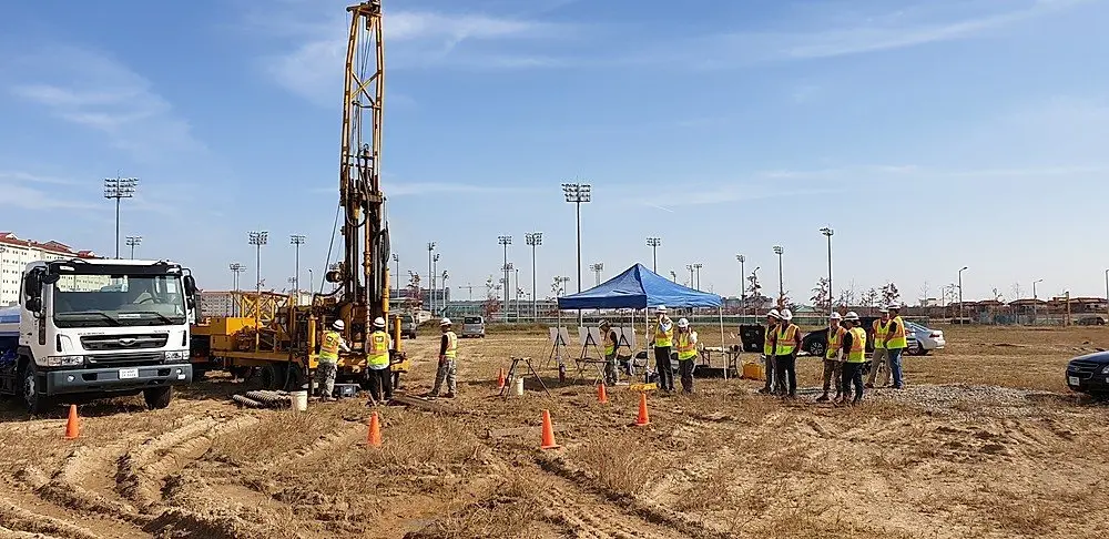
Geotechnical site investigation -
Geometrics Geode seismographs in the field -
Geophone spread for seismic refraction -
Vehicle-mounted PEG-40 accelerated weight drop -
Geophone spread for a MASW survey -
Seismic refraction tomography velocity section -
2D MASW layout and shear-wave velocity section -
Crosshole seismic tomography layout -
Downhole seismic survey layout
Marine geophysics
Seabed, sub-seabed and route surveys.
We carry out marine surveys for oil and gas exploration, geotechnical and civil engineering, offshore mining, nearshore environmental work and other seabed mapping projects. Our teams use marine acoustic and seismic mapping and sub-bottom profiling systems, side-scan sonar, marine magnetometers and bathymetric systems.
Survey methods are chosen according to the objective, water depth, required resolution and environmental conditions. We cover pre-survey planning and geophysical modelling, field support for acquisition and operations, 2D and 3D processing, interpretation and image mapping.
Applications
- Single and multi-streamer oil and gas surveys
- Geological mapping of the seabed and sub-seabed
- Seabed and sediment classification
- Pipeline and cable route surveys
- Marine UXO surveys
- Shallow hazard assessment
- Marine archaeology
- Port, coastal and geotechnical works
- Hydrographic surveys
Methods used
- High-resolution multichannel seismic reflection and refraction (2D/3D)
- Multibeam bathymetry
- Side-scan sonar
- High-resolution sub-bottom profiling
- Marine magnetometer surveys
- Underwater MASW and ERT
-
Marine seismic survey -
Near-shore underwater seismic refraction sections
Environmental
Contamination, waste sites and buried objects.
Characterising the subsurface, groundwater and soil is a key part of environmental site assessment and remediation. We use geophysics to map site hydrogeology, preferential contaminant pathways and the extent of contamination, and to locate buried debris and objects of concern.
Brought into the first stage of site characterisation, a geophysical survey gives a fast, cost-effective and detailed picture of the near surface and helps plan drilling, monitoring and remediation more efficiently.
Applications
- Soil and groundwater contamination and leaks
- Landfill, trench and waste pit boundaries
- Chemical and municipal waste sites
- Underground wastewater storage zones
- Buried objects: pipes, fuel tanks, drums
- Unexploded ordnance (UXO)
- Freshwater and saltwater boundaries
- Dam and lake leakage
- Subsurface cavities
Methods used
- Seismic refraction tomography
- Electrical resistivity tomography (ERT)
- Ground-penetrating radar (GPR)
- Electromagnetics
- Magnetics
- Soil gas: radon, thoron and CO₂
- Borehole logging
-
Multi-electrode resistivity (ERT) survey -
3D resistivity fence diagram
Archaeological geophysics
Buried structures mapped before excavation.
Near-surface geophysics is now widely used in archaeology because it maps large areas quickly, reduces or avoids destructive excavation, and detects the physical traces of features that cannot be seen at the surface.
We survey archaeological sites with current magnetic, radar, resistivity and electromagnetic instruments and deliver the results in GIS, so that excavation teams can plan precisely where to dig.
Applications
- Walls, foundations and buried structures
- Tombs, chambers and cavities
- Kilns, hearths and burnt features
- Site extent before excavation
- Underwater and coastal sites
Methods used
- Magnetics and magnetic gradiometry
- Ground-penetrating radar (GPR)
- Electrical resistivity tomography (ERT)
- Electromagnetics
- Microgravity
-
Geophysical survey at an archaeological site -
Magnetic anomaly map over an archaeological site
Forensic geophysics
Non-destructive searches for investigators.
Geophysics makes it possible to search without disturbing the ground. We support police and judicial teams in locating concealed buried objects, hideouts, storage spaces, escape tunnels, missing persons and graves.
Surveys are planned with the investigating team, run with non-destructive methods and reported with maps that show exactly where to excavate.
Applications
- Concealed buried objects
- Hideouts, bunkers and storage spaces
- Escape tunnels
- Clandestine graves
Methods used
- Ground-penetrating radar (GPR)
- Magnetics
- Electrical resistivity tomography (ERT)
Request for Proposal
Upon receipt of information on the project objective, survey area and schedule, we will submit a proposal setting out the appropriate method, work programme and deliverables.